CMP, Emera on alert as Nor'easter bears down with high winds
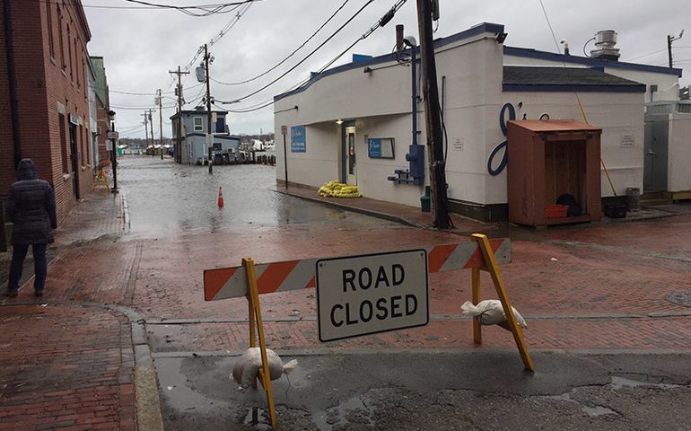 Photo / Peter Van Allen
Portland Pier was closed midday Friday, just after the high tide, due to the storm surge from today's Nor'easter. At right, J's Oyster Bar had sandbags at the back door.
Photo / Peter Van Allen
Portland Pier was closed midday Friday, just after the high tide, due to the storm surge from today's Nor'easter. At right, J's Oyster Bar had sandbags at the back door.
Central Maine Power Co. and Emera Maine both said they were preparing for a Nor’easter today that’s expected to bring wind gusts up of 50 miles an hour along Maine’s coast.
A high wind warning from the National Weather Service remains in effect until midnight, with the strongest winds likely to hit Friday afternoon and evening.
CMP said its storm readiness teams have been holding planning meetings — adding that it’s pre-positioning personnel and equipment, including 100 additional contract crews from Maine and Canada, to handle potential power outages.
Forecasts call for northeasterly winds to increase throughout Friday and continue during Saturday, with CPM cautioning that winds could bring tree limbs into contact with power lines, increasing the risk of outages.
While the storm isn’t expected to make a direct hit in Maine, the main problems will be strong winds and coastal flooding that one meteorologist said could rival the Jan. 4 Nor’easter. Precipitation forecasts call mainly for rain, and a wintry mix in the mountains.
Emera said its storm response team is monitoring the forecast and will adjust plans if predictions change. External and internal crews will be positioned in areas where the storm is expected to have the most impact, it added.
“Small changes in the track of this storm could have a large impact on wind predictions, and we will continue to watch the weather while we gear up for a safe response,” said Emera Maine storm managers Kevin Peterson and Tim Pease in a statement.
Customers are reminded never to touch a downed power line or a tree in contact with one.
USGS deploys sensors to measure coastal storm surge
U.S. Geological Survey field crews have deployed storm-tide and wave sensors from Maine to Delaware to track and study Friday’s Nor’easter.
These sensors will continuously measure wave height and tide levels and provide information on the timing, duration and extent of flooding. Data is collected four times per second, providing a detailed picture of the storm.
More than 25 USGS scientists will deploy over 50 sensors along the coast of Maine, New Hampshire, Massachusetts, Rhode Island, Connecticut, New York, New Jersey and Delaware.
The information gathered will help federal and state officials, emergency managers and coastal planners understand storm processes and ultimately build more resilient communities. Data will help fine-tune and improve the accuracy of models that forecast storm surge, inundation, erosion, dune loss and other coastal changes. This information also helps guide recovery efforts, helping identify areas hit the hardest by the storm and inform decisions to improve structure designs and increase public safety.
“Nor’easters can cause higher storm tides than hurricanes in the Northeast and mid-Atlantic,” said USGS New York Water Science Center supervisory hydrologist Ronald Busciolano. “Many of the highest recorded tides in these areas were from these types of storms.”
Busciolano added that every Nor’easter is unique, which makes data from real events essential to improving USGS’s understanding. “The more real-world data we can collect on a variety of storms and tracks, the more precise and informed forecasts can be for future scenarios,” he said.
All sensors will be collected next week — when it is safe to do so — and data will be analyzed and available in the following weeks. All data will be available via the USGS Flood Event Viewer.
These sensors are part of a relatively new USGS mobile network of rapidly deployable instruments to observe and document storm-surge, waves and tides as they make landfall and interact with the coast.
The USGS Total Water Level Viewer provides forecasts on the potential for beach erosion, overwash and inundation for Hurricanes and other severe coastal storms.
Most Recent


Most Recent


Comments