Bangor co. puts itself on the map
 photo/Amber Waterman
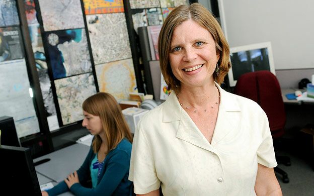
Claire Kiedrowski, president of Kappa Mapping Inc. in Bangor, oversaw 28% growth in earnings last year
photo/Amber Waterman
Claire Kiedrowski, president of Kappa Mapping Inc. in Bangor, oversaw 28% growth in earnings last year
 photo/Kappa Mapping
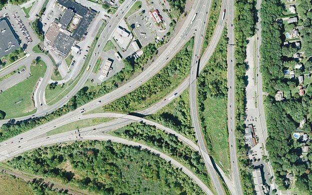
Aerial imagery and mapping: Cameras capture images from aerial positions that are planned in relation to a layout determined by the project's goals. Airborne GPS and other data, including LiDAR (for light detection and ranging), can be included for special purposes.
photo/Kappa Mapping
Aerial imagery and mapping: Cameras capture images from aerial positions that are planned in relation to a layout determined by the project's goals. Airborne GPS and other data, including LiDAR (for light detection and ranging), can be included for special purposes.
 photo/Kappa Mapping
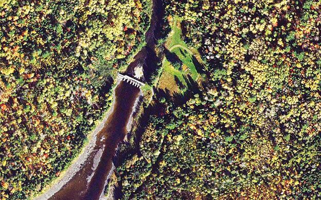
Softcopy photogrammetry: Accuracy of aerial photographs is ensured using CAD and GIS software, then ground coordinates are triangulated through layers of photos. Useful for purposes such as creating a topographical map of a farmer's fields to reveal the slopes and sun exposure of the farmland.
photo/Kappa Mapping
Softcopy photogrammetry: Accuracy of aerial photographs is ensured using CAD and GIS software, then ground coordinates are triangulated through layers of photos. Useful for purposes such as creating a topographical map of a farmer's fields to reveal the slopes and sun exposure of the farmland.
 photo/Kappa Mapping
Digital orthography: A digital image with the geometric qualities of a map that's derived from a digitized aerial photograph corrected for distortions caused by camera tilt and relief of terrain
photo/Kappa Mapping
Digital orthography: A digital image with the geometric qualities of a map that's derived from a digitized aerial photograph corrected for distortions caused by camera tilt and relief of terrain
 photo/Kappa Mapping
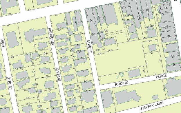
Geographic Information Systems: Technology that converts collected data into a mapping format that enables viewers to visualize, question, analyze, interpret and understand the map to reveal relationships, patterns and trends
photo/Kappa Mapping
Geographic Information Systems: Technology that converts collected data into a mapping format that enables viewers to visualize, question, analyze, interpret and understand the map to reveal relationships, patterns and trends
In the summer of 2009, scientists with the Maine Department of Marine Resources were eager to pin down how Maine's lobster population might be affected by the number of traps being set. Given the importance of the lobster fishery to the state's economy — the 2011 catch was worth $345 million — the research was driven by concerns about the industry's long-term sustainability.
Getting an accurate buoy count would give the scientists a benchmark for exploring a working hypothesis that an equal number of lobsters might be caught with fewer traps, which would decrease costs and add efficiencies to lobster-fishing operations.
But as researchers began their trap study in a 3.5-square-nautical-mile section off Tenants Harbor, they faced an obvious challenge: In a constantly moving ocean, how do you count thousands of pot buoys without losing track? Hand-counting from a boat would be prone to miscounting. Relying on lobster licensing records also is unreliable, since the number of traps can vary widely in relation to the seasonal movement of lobsters. In other words, it's not a simple multiplication problem.
DMR researchers turned to Kappa Mapping Inc., a woman-owned business in Bangor with eight employees and 2011 revenues of $754,000. The 2009 project illustrates how advances in technology have revolutionized the mapping industry, providing useful information to researchers, engineers, municipal planners, architects and others that 15 years ago would have cost a small fortune to present visually … if it could have been at all.
"We used traditional technologies in an innovative way," says Claire Kiedrowski, president of the nine-year-old company in the heart of Bangor's downtown. In the 2009 Tenants Harbor study, Kappa contracted with James W. Sewall Co. to take aerial photographs of the harbor once a week for several consecutive weeks in July and August. The specs were exacting: The images were to be taken at low tide, calm seas, early morning, and overcast skies to minimize sun glare on the water.
The traditional technology Kappa used falls under the tongue-twisting tag of "photogrammetry." It involved stitching together multiple overlapping photos to create a high-definition composite image of the Tenants Harbor study zone. The innovative part, which earned Kappa a prestigious MAPPS excellence award for small projects in 2010, involved matching buoys in adjacent photos and using navigation-grade GPS photo positions to triangulate the imagery.
Kappa's mapmaking team in Bangor then meticulously created an accurate map showing the location of each and every buoy in the waters off Tenants Harbor — ranging from 9,000 to a high count of 10,450 early in the study period.
Kiedrowski describes that 2009 project as "not that big for us," but it clearly opened the eyes of DMR's marine scientists to the value of using photogrammetry as a highly accurate tool for better understanding the lobster fishery. The next fall, DMR hired Kappa to manage a similar study of traps along the entire coast of Maine … in this instance, using an advanced large-format digital camera to collect three separate spectrums of visual data — true color, color infrared and black-and-white — at the same time. That information is being used to evaluate the risk of endangered right whales becoming entangled in lobster trap lines.
Most recently, Woolpert Inc., a prominent aerial photography firm based in Dayton, Ohio, signed up Kappa Mapping and Shyka, Sheppard & Garster Land Surveyors as subcontractors for a five-year mapping of the entire state that will make available high-resolution aerial photographs of Maine towns and cities that can be used for planning, assessing, code enforcement, emergency management, growth projections or management of natural resources and agriculture. The project is being coordinated by the Maine GeoLibrary. The data also can be used as the base map for E-911, roads and other uses requiring high accuracy imaging.
Technology and mapmaking
Kiedrowski's path to being president of a computer mapping firm runs parallel to changes in the mapping and surveying industries.
As a new University of Maine graduate in 1990, Kiedrowski thought she'd be a surveyor. What appealed to her is the way surveying combined historical research using titles and deeds with advanced technological tools. It's a mathematical discipline that's married to historical and visual reference points.
Fast forward 20 years and her job entails all of that, with some significant additions. Each surveying job added to Kiedrowski's skills as she kept pace with rapidly evolving changes in the mapping and surveying industries.
She learned photogrammetry, defined as the "science of making measurements from photographs" that typically are presented in a map, or drawing or three-dimensional model of a real-world object, such as a proposed highway interchange, or a scene such as Tenants Harbor. She also learned orthophotography, which delivers an aerial photograph geometrically corrected so the scale is uniform and without distortion. Unlike an uncorrected aerial photograph, an orthophotograph can be used to measure true distances, because it is an accurate representation of the Earth's surface, having been adjusted for topographic relief, lens distortion and camera tilt.
And there's GIS, the acronym for geographic information system, which marries cartography, statistical analysis and database technology to create maps that might show drainage patterns, housing density or potential obstacles in an airport's flight path.
Kiedrowski readily admits that changes in mapmaking and surveying benefit largely from the advances in digital photography, as well as imaging and 3-D graphics software that owe more than a little to video games pioneered by Nintendo and Sony, which earned billions in annual revenues through the 1990s.
"All those simulated 'fly-throughs' you see [in video games] represent a significantly bigger market segment than photogrammetry remote sensing, surveying or mapping," she says, explaining that video game technology is what allowed high-end photogrammetry to be performed at individual desktop computers.
A change in purpose
In 2003, Kiedrowski was working for a firm owned by The Boeing Co. that made photogrammetric mapping software. She and her business partners purchased a well-established aerial mapping firm in downtown Bangor, quite literally, lock, stock and barrel. They took over the firm's equipment, its building, most of its clients and all its staff. Kappa's website describes the 2003 purchase as "a good investment since each employee brought expertise in parcel mapping, GIS, and other photogrammetric mapping services. Many still work with us."
From a personal standpoint, Kiedrowski's life changed in an important way.
"I went from being a software supplier to being a service provider," she says. "Working for Boeing, I was employee No. 11560. My upper management would change, overnight, and no one had asked our opinion about it, one way or the other. No one gave me a bigger picture of what the role of our division was and how I would be part of it. I was in my early 40s and wanted to be part of something I could develop and grow."
The company Kiedrowski now heads takes advantage of technology, the creative can-do mindset she shares with her co-workers and a growing reputation as a company that can manage a project from start to finish, or serve as a subcontractor for much larger national mapping, engineering or surveying companies that appreciate Kappa's ability to handle a variety of mapping projects.
"We really excel at both," she says, comparing the subcontractor role to "cooking in their kitchen, using their recipes and tools."
Still, Kiedrowski acknowledges there's a special thrill to managing a project from start to finish — in large measure because it builds the corporate resumé and enhances the Kappa brand as a company capable of providing high-quality photogrammetric and GIS services to solve a wide array of complex problems.
"I consider myself and my employees as an ensemble," she says. "We're all pretty fluid in terms of the hierarchy here. Sometimes an employee takes the lead role and has a 'solo,' sometimes they step back and let someone else have the solo."
Being a woman-owned business that's also certified by both the Maine Department of Transportation and the Federal Highway Administration offers competitive bidding advantages for certain types of work, she adds.
The portfolio
Kiedrowski hesitates to predict Kappa Mapping's future, other than to say she's hopeful she can double her work force in the next five years and continue doing "the type of projects that really motivate us and sustain us and make us want to get up in the morning to head into work."
That hesitancy, in part, stems from the not-so-long-ago feeling that her company was "really poised to take off" — in her words "we had the right team, the right software, the right location and the right relationship with our clients" — only to have the 2008 financial crisis hit home with a big thud at 6 State St. in Bangor.
"I had to lay most everybody off," she says. "That was really scary."
Kiedrowski says her employees understood the economic realities and worked with her to keep the business open. They accepted reduced hours and salary while she maintained everyone's benefits. Employees used the down time to expand their skills, learning new software and taking on unfamiliar tasks (such as writing proposals). By spring 2009, her employees were back to full-time status.
The adversity of weathering the deepest recession since the Great Depression proved to be a time of growth for everyone, including Kiedrowski.
"It's easy to lead when things are going well," she says. "But how do you lead when the cash flow is not going well, and you have a difficult client making unreasonable demands, and both of those things are coming together at the same time? … My goals now are very different than they were in 2003."
Coming out of the recession, Kiedrowski and her team have expanded Kappa's client list, built an award-winning portfolio and seen revenues steadily grow — with last year's gross earnings of $754,000 representing a 28% increase over 2010.
Recent projects include:
- As a subcontractor, Kappa used orthophotography and other mapping tools to create a topographic map, with 2-foot contour intervals, that enabled the The Boutet Co. to develop a 3-D model for a proposed 100-megawatt wind farm project in Anchorage.
- Working with the Bangor surveying firm of Shyka, Sheppard and Garster, Kappa did the base mapping for Hollywood Slots, Bass Park and the Cross Insurance Center that's now under construction.
- Transportation mapping for the Penobscot Narrows Bridge, Interstate 295 in Portland and Auburn-Lewiston Municipal Airport.
- Using color infrared orthophotography to identify significant vernal pools in Bar Harbor. Kappa completed new maps for the town's assessor that were linked to a digital database.
Each example in the company's portfolio represents a successful application of fast-evolving mapping technologies to solve a particular problem. For Kiedrowski and the other members of her team, that's the thrill of it.
"I'll grab the opportunities as I see them," she says. "What does that look like and what will it mean for this company five years from now? I don't know. But it will be fun to get there."
Editor's note: This is a corrected version of the original story. It corrects revenue figures for Kappa Mapping.
Most Recent


Most Recent


Comments