Belfast highlights flood risk as part of fed program
 Courtesy / NOAA, City of Belfast
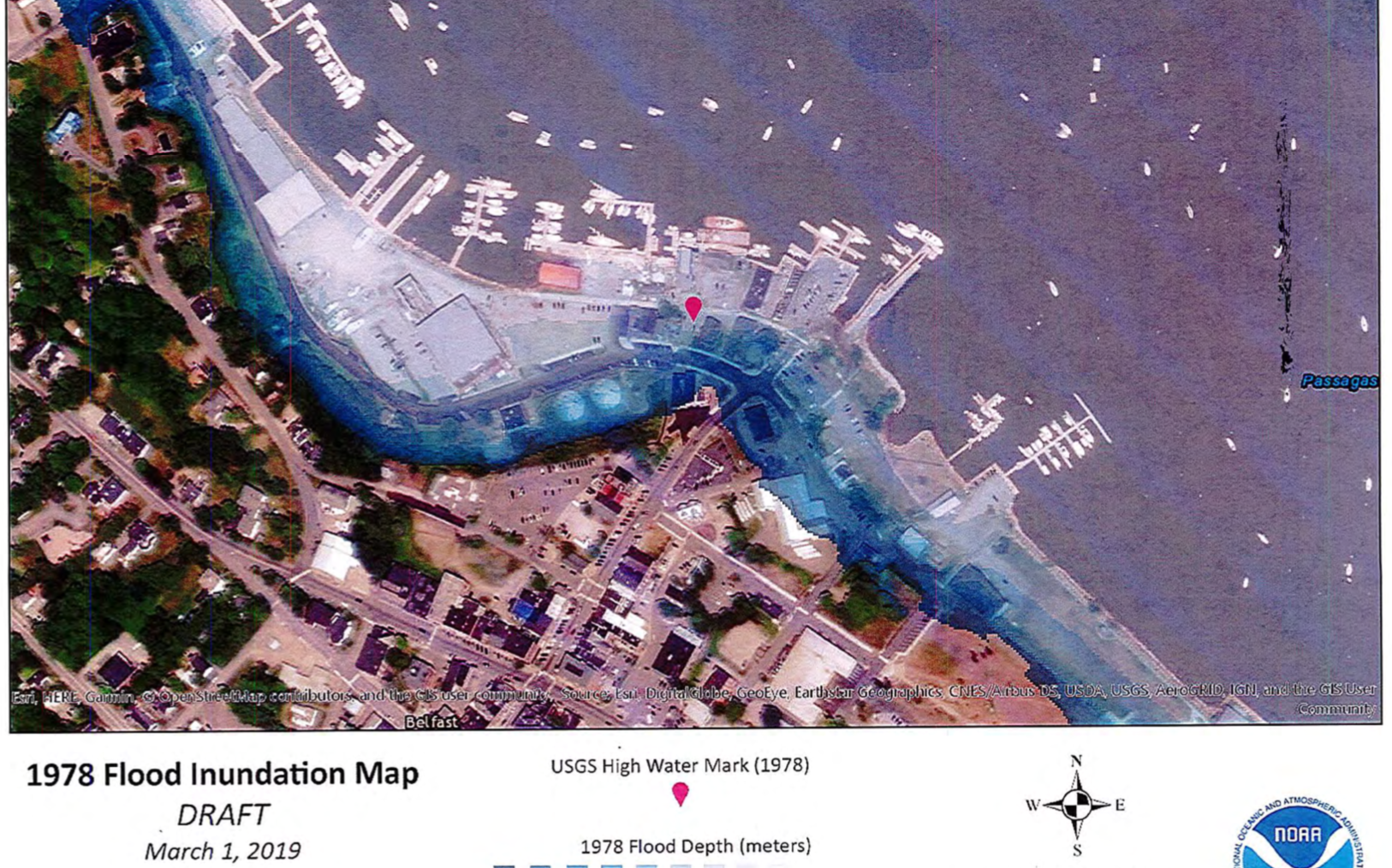
The dark blue shading indicates flood inundation along a portion of Belfast Harbor during a 1978 storm.
Courtesy / NOAA, City of Belfast
The dark blue shading indicates flood inundation along a portion of Belfast Harbor during a 1978 storm.
The Belfast City Council has agreed on a couple of high-visibility spots to site high-water markers, as part of the city’s participation in a federal project to open public discussion around flood risks.
At the council’s Aug. 20 meeting, Harbor Master Katherine Pickering explained that the project is part of the U.S. Army Corps of Engineers’ National Flood Risk Management Program, and is being implemented at the state level by the Maine Silver Jackets Program.
The National Flood Risk Management Program works to coordinate programs to reduce flood risk and create public awareness, she wrote in a memo to the council.
The city of Belfast submitted a letter of interest in March and in June that it had received funding, along with South Portland and Scarborough, to participate in the High water Mark project.
“Because the main goal of this program is public awareness, the high water markers are designed to attract attention and are located in high-visibility areas,” she wrote. “They can be customized to fit the landscape and include information to connect residents with additional educational materials available.”
The existing high water markers in Belfast are based on data from a February 1976 storm and January and February 1978 storms, she said.
Municipalities are allowed $2,500 in funding to cover the survey work, construction and installation of the markers.
A meeting is scheduled Sept. 17 to look at current marker locations and potential new locations.
Front Street stakes
Pickering and Jon Beal, a member of Belfast’s climate change committee, said that most towns that have participated in the project have installed one marker. They said they’d like to see two markers in Belfast. That’s because of the greater risk of flooding since the 1970s storms, said Beal.
“I’ve been wishing someone would do this for 10 years,” said Councilor Michael Hurley, who suggested installing markers on the Harbor Walk and on Front Street.
“I think Belfast will want to know what’s happening to Front Street, especially behind the Front Street Shipyard,” he said. “Having survey points that are easy to take off a post at Front Street would be really helpful.”
Councilor Paul Dean suggested instead a marker along Main Street, as a dramatic illustration of just how far a storm surge might reach.
“Pick out the places that would best dramatize where the water could go in the future,” said Hurley.
The council decided on Harbor Walk and Armistice Bridge at the confluence of the bridge and Harbor Walk.
According to a 2018 report of Belfast’s climate change committee, wind, waves and flooding generated by three severe storms from October 2017 through March 2018 caused damage in and around Belfast Harbor.
The October 2017 storm, with winds of 43 miles per hour, drove water up the bay; storm surge in Belfast Bay measured 3.3 feet. During a Jan. 4, 2018, storm, the surge in Belfast Bay measured 2.8 feet.
The report said that, during the February 1976 storm, Bangor experienced a historic flood in which downtown water level reached 17.46 feet, a storm surge of approximately 10.5 feet above the predicted astronomical tide.
As part of the National Flood Insurance Program, the High Water Mark Initiative is a community-based awareness program that increases local communities’ awareness of flood risk and encourages action to mitigate that risk, according to the Federal Emergency Management Agency.
As part of the project, communities post high water mark signs in prominent places, hold a high-profile launch event to unveil the signs, conduct ongoing education to build local awareness of flood risk, and complete mitigation actions to build community resilience against future flooding.
Flooding is one of the leading forms of natural disaster in the United States. Large storms such as Hurricanes Harvey and Maria have ravaged communities, costing billions a year in recovery, restoration, and rebuilding. However, less than 30% of respondents to FEMA’s national Flood Risk Awareness Survey believed their communities were at risk of flooding.
In May, officials in Portland announced the planned installation of High-Water Mark signs across that city to increase awareness of flood risk.
At that time, Portland was one of two places in Maine selected for the project. Portland and York were Maine’s pilot project sites for the initiative. In Portland, four sites will receive the signs: Portland Pier, Eastern Prom Trail, Back Cove, and Stroudwater (Fore River Trail).
In February 1978, the “Blizzard of 1978” caused unprecedented flooding that resulted in more than $20 million in damage to public and private infrastructure in Maine due to coastal flooding, tidal surge, and high winds.
Most Recent


Most Recent


0 Comments