UMaine leads development of tool to track PFAS nationwide
 Courtesy / University of Maine
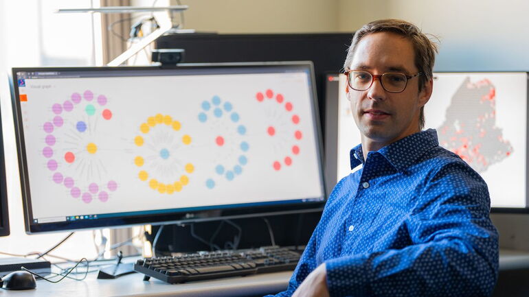
University of Maine computer scientist Torsten Hahmann with a prototype of a new PFAS tracking tool he's developing called Safe Agricultural Products and Water Graph (SAWGraph).
Courtesy / University of Maine
University of Maine computer scientist Torsten Hahmann with a prototype of a new PFAS tracking tool he's developing called Safe Agricultural Products and Water Graph (SAWGraph).
A new interactive digital tool could help analyze data on sites and sources of contamination by toxic per- and poly-fluoroalkyl substances, or PFAS, in water supplies, farms and the environment.
“There is a ton of data out there and plenty of people are testing, but nobody knows how it all fits together,” said University of Maine computer scientist Torsten Hahmann, who is spearheading the tool’s development. “We are building connections among different pools of data.”
The emergence of PFAS in water supplies, farms and the environment is a growing problem nationwide. Many researchers and government agencies are investigating the so-called “forever chemicals.” But to date, there has been no tool for combining findings and providing a comprehensive view of the problem, according to a news release.
The interactive software, still a prototype, could help investigators and the general public track existing PFAS hotspots, which in turn can help them identify where to test for new ones and better understand how they travel through the natural and manmade environment.
The National Science Foundation awarded $1.5 million for the project. The project was one of 18 nationwide recently funded with a combined $26.7 million through the foundation’s Building the Prototype Open Knowledge Network (Proto-OKN) program.
Each project involves collaboration with a federal agency. Hahmann's team, which includes three UMaine doctoral students and scientists from institutions throughout the nation, is partnering with the U.S. Environmental Protection Agency to develop its PFAS tracking tool, called the Safe Agricultural Products and Water Graph.
“We’re really focused on getting a product out that the EPA can use for a long time,” Hahmann said.
PFAS have been used widely in industrial and consumer products such as nonstick pans, takeout food containers and firefighting foam since the 1940s for their resistance to grease, oil, water and heat. Research suggests that exposure to high levels of certain PFAS may lead to adverse health outcomes, including immune system disorders, thyroid hormone disruption and cancer.
Forever chemicals
PFAS are referred to as forever chemicals because they tend to break down very slowly or not at all. They can bioaccumulate in plants, animals and people. They have been found in wastewater sewage that farmers in Maine previously used as fertilizer. In response to concerns surrounding PFAS, the state banned the sludge spreading on land in 2022.
Like existing websites for tracking PFAS, the one powered by Hahmann’s SAWGraph will feature a map that displays contamination sites and are color-coded based on where and in what the PFAS have been found, including soil, surface or well water, farms, food, domestic or wild animals. It will also provide the same visuals and codifications for PFAS sources and areas where PFAS-containing wastewater sludge was used as fertilizer.
But a new feature provided by SAWGraph is the ability to connect that data with potential sources, impacts to food and water, and transport mechanisms of PFAS.
SAWGraph users can then break down the information based on the category of contamination and location, from the state to the municipal level. New data from state and federal agencies will automatically be uploaded into the software.
“We’ve been talking with Maine and federal agencies to see what they would like to see, what technology could make things better so they don't just have to use spreadsheets,” Hahmann said. “We can present multiple sets of data at once, which can help with rather complex queries about things people really want to know, rather than just show rows and columns of numbers.
Hahmann and several colleagues have been developing a prototype that includes only sites of contaminated soil and water in Maine, supported by seed funding from NASA’s Established Program to Stimulate Competitive Research (EPSCoR) Research Infrastructure Development program that was awarded by the Maine Space Grant Consortium.
The foundation’s funding allows his team to refine and expand the prototype.
With an abundance of data that users can organize based on their needs, Hahmann said the SAWGraph can help answer various questions about PFAS contamination. For example, they can look at data from all of the wells located downstream from a water source polluted by PFAS. They can see what counties that have undergone testing have the highest and lowest levels of PFAS contamination and prioritize further testing accordingly.
Based on the location of pollution sites, they can explore whether nearby food or water supplies are threatened by “forever chemicals.”
Hahmann said the SAWGraph is expected to be able to help determine what other data are needed to tackle the PFAS problem on a national scale. Additionally, it might help users identify possible threats to properties, and state and federal agencies determine where additional testing might be most urgent.
Most Recent


Most Recent


0 Comments