Maine river conditions mean drought may continue, but flood risk is low
 Courtesy / U.S. Geological Survey
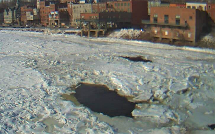
An image of the Kennebec River in Augusta Friday morning, from the U.S. Geological Survey camera mounted under the Calumet Bridge. The Maine River Advisory Commission has determined the flooding risk this year from snow melt along Maine's rivers is low.
Courtesy / U.S. Geological Survey
An image of the Kennebec River in Augusta Friday morning, from the U.S. Geological Survey camera mounted under the Calumet Bridge. The Maine River Advisory Commission has determined the flooding risk this year from snow melt along Maine's rivers is low.
The risk of the state's rivers flooding as the snow melts this year is not great, but the bad news is Maine could be headed for another drought, the River Flow Advisory Commission has determined.
The commission held its annual meeting Thursday to discuss ice conditions, flood risk and drought possibilities across the state. The commission is part of the Maine Emergency Management Agency and its members include representatives from the U.S. Geological Survey, National Weather Service, U.S. Coast Guard, energy and other industries, state departments and more.
The commission determined there is low to below-normal stream flow and ground water conditions across Maine and, without more precipitation, dry conditions will likely continue into summer. The snow pack is normal to below normal, and there is a below normal risk for river flooding, the commission said.
"If we have a really mild spring we may be looking at a drought again," Co-chair Robert Lent said in the commission's report. "But if we do get precipitation, I think we agree that the potential of spring flooding is normal to below normal."
The state had a drought for most of 2020, which had an impact on crops and wells. The drought, which began in May, continued through the summer, with September being the driest on record for the state, according to the National Weather Service. The U.S. Department of Agriculture declared a disaster and offered federal disaster relief to farmers in 14 of the state's counties, with only Hancock and Knox excluded. Currently, center-western Maine and the coast are still in drought, according to the U.S. Drought Monitor.
Even though snow levels are low, that doesn't mean there isn't a spring flood risk, said Nicholas Stasulis, data section chief for the U.S. Geological Survey.
So far, the U.S. Coast Guard has clocked 180 ice-breaking hours, all on the Penobscot River in Bangor. That's considered a light season for the operation, its representative said. Another ice breaking mission is planned by the Coast Guard from March 22 to 25. The Coast Guard breaks up the ice on the Kennebec and Penobscot rivers in February and March not only to help oil barges move more freely on the rivers, but to lessen flood risk.
Maine's 'primary hazard'
The state's five major rivers and more than 5,000 streams and brooks are among the state's "most valuable natural resources as well as its primary hazard," according to MEMA. "In Maine, floods can happen during any season, but are most common in the spring due to the combination of steady rainfall and snowmelt."
Many of Maine's rivers flow from the mountains east to the coast, and those rivers rise fast during snowmelt and heavy rain. Ice jams along the rivers, particularly during the spring melt, add to the hazard.
Susan Baker, state coordinator of the Floodplain Management Program, said at the meeting that Maine is underinsured for flood protection. A new risk rating system from the Federal Emergency Management Agency will be released in October, with revisions to the flood insurance program, particularly for the Bangor area. Changes for coastal areas are also coming as the sea rises because climate change.
The River Flow Advisory Commission was formed after spring flooding in 1983 to improve the exchange of hydrologic information collected by members, review the data and provide information to emergency action agencies and the public. It was formally created in statute by the Maine State Legislature in 1997.
The state's major rivers, particularly the Kennebec between Skowhegan and Gardiner, are prone to small floods almost every spring. The most damaging recent major flood was April 1, 1987, the melting snowpack and a warm heavy rainstorm caused rainwater and melting snow to run over frozen ground. Both the Penobscot and Kennebec river basins had extreme flooding.
At least 2,100 homes were flooded, with 215 destroyed and 240 more sustaining major damage. Roads and bridges were destroyed and at least 400 small businesses were affected, causing more than $100 million in estimated damages, according to MEMA.
The commission is made up of members from the US Geological Survey, Department of Environmental Protection, the National Weather Service in Gray and Caribou, the Coast Guard, University of Maine, Maine Emergency Management Agency and the National Flood Insurance Program.
Mainebiz web partners
Most Recent


Most Recent


0 Comments