Rockland-based MacArthur fellow creates maps that highlight Indigenous lands
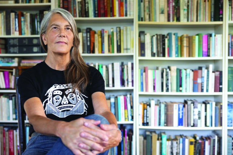 Photo / John D. and Catherine T. MacArthur Foundation, used with permission
Margaret Wickens Pearce, a cartographer based in Rockland, was named as a MacArthur Foundation fellow in October 2025.
Photo / John D. and Catherine T. MacArthur Foundation, used with permission
Margaret Wickens Pearce, a cartographer based in Rockland, was named as a MacArthur Foundation fellow in October 2025.
A couple months ago, Margaret Wickens Pearce received a string of calls her phone kept flagging as potential spam.
After swatting a number away to voicemail, Pearce finally received a text from someone from the Chicago-based MacArthur Foundation, asking her to speak on the phone. Shortly after hopping on the call, Pearce was told she was one of the 22 recipients of the 2025 MacArthur Fellowship, also known as the genius grant: an $800,000 no-strings-attached award used to support individuals working on innovative and groundbreaking projects.
MacArthur Foundation announced 2025 recipients on Oct. 8. She is one of three MacArthur fellows that have a Maine connection; the others are Passamaquoddy basket artist Jeremy Frey and biologist Toby Kiers, a Bowdoin College graduate.
Pearce, a cartographer, graduated with her master’s degree from Clark University in Worcester, Mass., in 1995 and with her PhD in 1998. A Citizen Potawatomi Nation tribal member, today she owns Studio 1:1 in Rockland, creating maps that highlight Indigenous land: telling stories of travel, collaboration, erased narratives and stewardship.
Worcester Business Journal: When do you first remember being drawn to the profession of cartography?
Margaret Wickens Pearce: I wouldn't say I was drawn to it as a profession. I was excited by maps, and it took me a long time to understand what that might mean in terms of making a living.
I started getting interested in the history of science when I was in college, and I was so captivated by learning about how cultures set up their maths and how they measured and what the history of mathematics was. I took a cartography class at the University of Massachusetts. And literally, the first week I was like “I don't know what's happening, but this is totally for me.”
I loved it was about measure but also about narrative. I loved that it allowed me to create compositions about different parts of the world.
I applied to Clark [University] and was accepted. Then that really got started for me to learn all about cartographic design, map history, geography, the history of geography, all of those interrelated fields that really helped me find my way as a cartographer.
WBJ: What was your first reaction when you heard that you had been named a MacArthur Fellow?
MWP: I felt very moved and just felt very quiet. I was honored and excited, but also immediately felt the responsibility of that fellowship, which I feel very powerfully. I'm so grateful to the MacArthur Foundation for trusting me with that responsibility. It's a huge honor.
I view it as an opportunity to put my dreams within reach. I view it as a responsibility I've carried all my life to use the skills and training that I've been given to make change, particularly for Indigenous people.
What projects are you planning on working on with this fellowship?
I have an immediate project, Mississippi Dialogues, that was already underway but was not completely funded because we had a grant through the National Endowment for the Humanities that was terminated. So these funds in the immediate future can complete the funding for that project.
It is a collaboration with Ho-Chunk Nation in Wisconsin and Prairie Island Indian Community in Minnesota for a public art project on the Mississippi River. We're doing these two large format cartographic panels: one will be installed in a public city park right on the river in Red Wing, Minnesota, and the other is going to be in a public land trust on the Mississippi River down in Illinois.
WBJ: You say you use cartography as a language. How did you come to that understanding and interpretation of the work?
MWP: It's actually a very traditional approach to cartography: that is cartography is structured by something similar to words and phrases and grammar. We have these graphic marks, like colors and shapes and lines, operating like words because they have meaning in the map. We assemble them together to make phrases: like a symbol, if you just imagine on a map a symbol for a historic town on the river, you expect that symbol to look in a particular way. So you're getting phrasing in the map.
Then all of the rule systems we use to put the maps together: the map projection, categories, and data classification. Those are all a kind of a grammar tying all the symbols together, so it has a structure like written language.
That's not the way that people generally think about it in society, at least in American society. There's a more passive view: whatever the phone is telling you is the route. But those digital maps are authored, and there are choices behind the way those symbols and those graphic phrasings have been put together. The more we think about them as writing or as language, the more we can imagine how they can be shaped to express other ways of living in the world just the same way we shape writing.
WBJ: In your MacArthur Fellowship video, you said that you see cartography as a way of writing about concepts that are hard to convey in linear text. What are some concepts people walk away with a better understanding after viewing your maps?
MWP: Something that's significant to Indigenous experience: The land is the most important thing. It's more important than anything. Cartography is a two-dimensional expressive space about the land. So the land is at the center of that narrative at all times. You can go further with that and make the land into a character or a collaborator in the telling of that narrative.
Another aspect of Indigenous experience: Time is not linear. Time is something that is a sequence of events in the landscape. So if you want to show time in a different way, you can use this two-dimensional space to portray sequential events as having also a kind of simultaneity, because we think of time as being always: everything is potentially present in time.
WBJ: Why do you think graphic representation of Indigenous peoples land is so important?
MWP: A visual representation, or a graphic representation, specifically, is a way of rendering visible people who are often made invisible in colonial circumstances. A graphic representation’s symbols, similar to letters, allow us to imagine in spaces. I can create a space for imagining what is there and how my life connects to the events that are being portrayed in the map, because there is a little bit of a little bit of a gap allowed.
For example, if I'm reading a story in linear text, and it's line by line, it's going to give me a very different experience than if I am, for example, reading that same text in a map where I can carve my own path through that narrative.
I might be reading those sentences in a different order, or seeing how they are situated with respect to the town where I live. It allows different dimensions of experience and of empathy to come forward that may not be present in other forms.
This interview was conducted and edited for length and clarity by Worcester Business Journal Staff Writer Mica Kanner-Mascolo. Worcester Business Journal is a sister publication of Mainebiz.
Mainebiz web partners
Most Recent


Most Recent


")


0 Comments