Rezoning for Irving's Aroostook County mixed-use development approved
 Courtesy / Irving Woodlands LLC
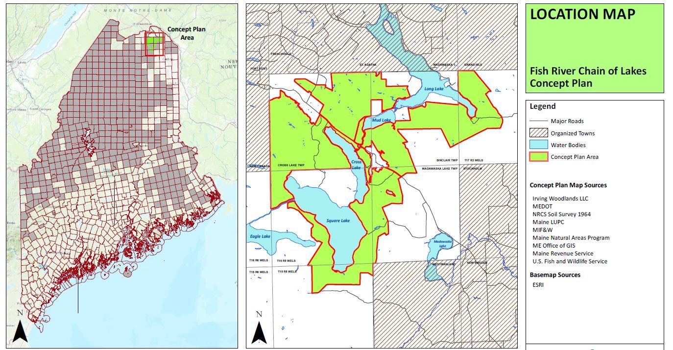
A map from the Fish River Chain of Lakes concept plan shows the area that has been rezoned for development.
Courtesy / Irving Woodlands LLC
A map from the Fish River Chain of Lakes concept plan shows the area that has been rezoned for development.
More Information
A rezoning that gives Irving Woodlands LLC a go-ahead to open 1,923 acres to residential and commercial development in northeastern Aroostook County, and preserve another 16,754 acres as conservation land, was approved by the Land Use Planning Commission Wednesday.
Irving's Fish River Chain of Lakes concept plan depended on rezoning from the commission, which oversees the state's Unorganized Territory, before going forward. The plan, proposed in 2017, calls for up to 330 residences, a small commercial development area and four community and economic development areas. Most development in the rest of the plan areas would be restricted under the agreement.
The concept plan does not authorize specific residential or commercial development to begin, but establishes a process through which Irving may sell leases and identifies areas where development may be located in the future after additional permitting reviews, the LUPC said in a news release.
The plan establishes procedures for sale of existing leased lots that protect residents’ road access and lake water quality, and the conservation land plan preserves long-term public access to lakes, and guarantees public recreational trail access, the release said.
The Fish River chain of lakes is an area of five lakes north and west of Caribou and south of Frenchville, and comprises about 51,000 acres in six townships owned by Irving, doing business as Allagash Timberlands LLC, Aroostook Timberlands LP and Maine Woodlands Realty Co.
The rezoning includes eight current zone subdistricts — General Development, Residential Development, General Management, Flood Prone Protection, Fish and Wildlife Protection, Great Pond Protection, Shoreland Protection, Wetland Protection — and changes them to a Resource Plan Protection subdistrict.
After a 2018 public hearing at which area residents said they opposed it, citing concern about impact on the environment from construction and increased residential use, as well as access to traditional recreational areas and the fate of leased camps, Irving made several changes, the LUPC said in an Aug. 29 memorandum on the project.
Changes include adding more than 2,000 acres to the permanent conservation easement — protecting routes for wildlife movement across the landscape, adding a number of protections regarding development and mining, eliminating "marina" from a proposed use, and strengthening provisions for public ownership/long-term lease of public water access sites and more.
With the approval, the plan is effective Sept. 26. The commission will hold a public meeting on Wednesday, Sept. 25, in Caribou.
Mainebiz web partners
Most Recent


Most Recent


0 Comments