State grants will address dams, water supply and coastal erosion
 Courtesy / Google Earth, Town of Camden
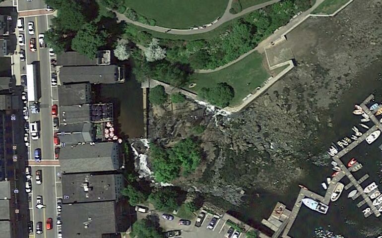
A $40,000 state grant will help Camden complete engineering and design plans for the partial or full removal of Montgomery Dam and reconfiguration of the seawall and adjacent area in Camden’s Harbor Park. This view shows Montgomery Dam and the lower impoundment location. Main Street (U.S. Route 1) is located at left.
Courtesy / Google Earth, Town of Camden
A $40,000 state grant will help Camden complete engineering and design plans for the partial or full removal of Montgomery Dam and reconfiguration of the seawall and adjacent area in Camden’s Harbor Park. This view shows Montgomery Dam and the lower impoundment location. Main Street (U.S. Route 1) is located at left.
Four coastal communities have won planning grants this week to address potential impacts of sea level rise and other challenges.
The Municipal Planning Assistance Program, part of the Maine Department of Agriculture, Conservation and Forestry, awarded a total of $143,229 to four projects through its Coastal Community Grant Program, according to a news release.
This year’s grants help coastal communities by supporting:
• Green infrastructure design to address run-off and erosion and restore coastal habitat;
• Dam redesign to provide for fish passage and improve inland and coastal resilience;
• Saltwater intrusion on island water supply;
• Work in economic vulnerability assessments of flood hazard impacts to coastal property and evaluating associated implications to municipal tax base, and developing locally relevant, strategies to help towns prepare for sea level rise.
Each project involves regional or local partnerships and each grantee provides a minimum of 25% in matching funds or services.
Grants were awarded to the following projects.
• Bustins Island Village Corp.: Green Infrastructure Design ($17,802)
Funds will support further analysis of upland hydrology and stormwater run-off which aggravates bluff erosion to inform detailed, actionable designs for green infrastructure to slow and retain upland rainfall. The goal of the project is to design adaptive green infrastructure to replenish the island's aquifer, restore native habitat, reduce stormwater run-off. "Living shoreline" bluff protection and repair will be examined in addition to other alternative designs.
Project Partner: Cumberland County Soil and Water Conservation District
• Town of Camden: Harbor Park Seawall and Montgomery Dam Redesign ($40,000)
Funds will help Camden complete engineering and design plans for the partial or full removal of the Montgomery Dam and the reconfiguration of the seawall and adjacent area in Camden’s Harbor Park. The project will result in a final design for modifications to the Montgomery Dam and reconfiguration of the adjacent seawall and adjacent area in Harbor Park to improve coastal and inland flood resilience and the passage of fish and other species from Camden Harbor up the Megunticook. Overall this project is an essential step in addressing more frequent storm surge events and improving the health of the entire watershed.
Project Partners: Island Institute, Megunticook Watershed Association, Coastal Mountains Land Trust, The Nature Conservancy, George’s River Chapter of Trout Unlimited
• Monhegan Plantation: Alternative Water Supply Feasibility Study ($39,240)
Monhegan and the Monhegan Water Co. will conduct a risk assessment of their sole source fresh water aquifer in light of recent studies predicting flood hazard scenarios related to sea level rise and increased storm surge. The study will examine current groundwater fed bedrock wells to gauge vulnerability to saltwater intrusion and evaluate the feasibility of drilled bedrock wells as a safer and more reliable alternative public water source for residents of Monhegan.
Project Partners: Island Institute, Lincoln County Regional Planning Commission, Monhegan Water Co.
• Southern Maine Planning and Development Commission: Tides, Taxes and New Tactics ($46,187)
Working closely with the municipalities of York, Kennebunk and Wells, the project team will investigate municipal-level economic and social impacts of sea level rise and storm surge hazards and develop locally-relevant adaptation and resiliency planning strategies that address local and regional vulnerabilities. The project team and advisory committee will use recently updated and downscaled sea level rise projections, storm surge modeling, and local tax and property data, to conduct an economic vulnerability assessment of flood hazard impacts to coastal private property, evaluate associated implications for the municipal tax base, and research, evaluate, and implement locally relevant, creative adaptation strategies to help towns and the region prepare for sea level rise.
Project Partners: Towns of York, Kennebunk and Wells, Wells National Estuarine Research Reserve, Maine SeaGrant, Island Institute
Mainebiz web partners
Most Recent


Most Recent


0 Comments