Courtesy / Saildrone Inc.
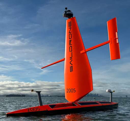
Bright orange 'saildrones' could be a startling sight for fishermen and other maritime users in the eastern Gulf of Maine.
Please do not leave this page until complete. This can take a few moments.
Two unusual vessels will soon be on the move in the eastern Gulf of Maine as part of a federal mapping project.
The 33-foot-long, bright orange sailboats carry no crew — they're drones, called Saildrone Voyagers. They will be deployed from Aug. 28 to Oct. 18, according to the National Marine Fisheries Service, an agency within the National Oceanic and Atmospheric Administration.
The Voyager is one of three models made by Saildrone Inc., headquartered in Alameda, Calif. The company's website says the vehicles, ranging from 23 to 65 feet long, have sailed almost 1 million nautical miles and spent nearly 25,000 days at sea collecting ocean data for climate, mapping and maritime security applications.
The drones combine wind-powered propulsion and radar, cameras and solar-powered sensors to perform data collection missions even in the harshest ocean environments. The Fisheries Service and Saildrone are using the drones for research that includes high-resolution mapping along the seafloor in predetermined tracklines.
The craft will also conduct sound velocity profile casts, which measure the speed of sound in the water column during survey operations. The casts are taken throughout most of the water column, but don’t contact the seabed and are not expected to interfere with fishing gear or other structures on the seafloor, according to a news release.
“Fishing vessel operators who use fixed gears should avoid setting gear in areas planned for survey to help limit any risk of entanglement between the Saildrone Voyagers’ sound velocity profile casts and vertical lines,” the Fisheries Service and Saildrone said in a joint statement.
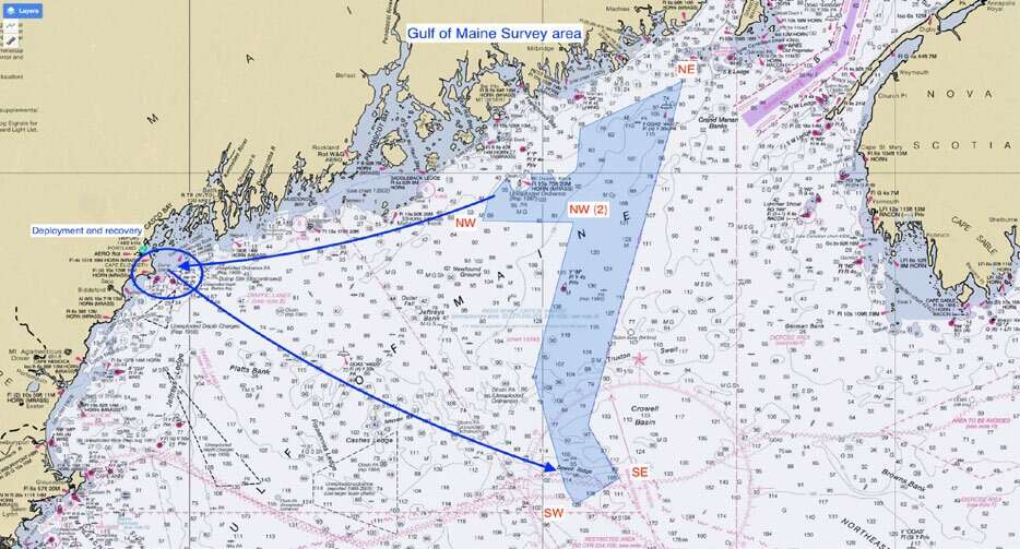
The survey will be conducted in a polygonal area whose northern side is off downeast Maine. But phase 1 of the survey will be focused on the southern portion of the survey area.
The two vehicles will be working in the same general section of the study area but could be 5 to 10 miles apart from each other. They operate at speeds between 2 mph and 5 mph, moving between a series of predetermined waypoints.
The drones will be under the constant supervision of a human pilot via satellite.

The Giving Guide helps nonprofits have the opportunity to showcase and differentiate their organizations so that businesses better understand how they can contribute to a nonprofit’s mission and work.
Learn More
Work for ME is a workforce development tool to help Maine’s employers target Maine’s emerging workforce. Work for ME highlights each industry, its impact on Maine’s economy, the jobs available to entry-level workers, the training and education needed to get a career started.
Learn More
Whether you’re a developer, financer, architect, or industry enthusiast, Groundbreaking Maine is crafted to be your go-to source for valuable insights in Maine’s real estate and construction community.
Learn moreThe Giving Guide helps nonprofits have the opportunity to showcase and differentiate their organizations so that businesses better understand how they can contribute to a nonprofit’s mission and work.
Work for ME is a workforce development tool to help Maine’s employers target Maine’s emerging workforce. Work for ME highlights each industry, its impact on Maine’s economy, the jobs available to entry-level workers, the training and education needed to get a career started.
Whether you’re a developer, financer, architect, or industry enthusiast, Groundbreaking Maine is crafted to be your go-to source for valuable insights in Maine’s real estate and construction community.
In order to use this feature, we need some information from you. You can also login or register for a free account.
By clicking submit you are agreeing to our cookie usage and Privacy Policy
Already have an account? Login
Already have an account? Login
Want to create an account? Register
In order to use this feature, we need some information from you. You can also login or register for a free account.
By clicking submit you are agreeing to our cookie usage and Privacy Policy
Already have an account? Login
Already have an account? Login
Want to create an account? Register
This website uses cookies to ensure you get the best experience on our website. Our privacy policy
To ensure the best experience on our website, articles cannot be read without allowing cookies. Please allow cookies to continue reading. Our privacy policy


0 Comments